AI Change Detection for Geotechnical Monitoring
IRIS automates landslide monitoring, rockfall monitoring, and slope surveillance through camera-based AI. Detect changes early, reduce site visits, and streamline reporting.
Deploy early warning — before changes become hazards

What is IRIS?
IRIS is an AI change detection platform developed by NHAZCA. It processes images and video streams from existing cameras, webcams, drones and remote archives to detect landslides, rockfalls, slope deformation and surface changes in near real time.
For geotechnical engineers, infrastructure owners and safety teams, IRIS enables landslide monitoring, rockfall monitoring, and slope surveillance with existing infrastructure. Deploy early warning before changes become hazards.
Choose How You Deploy IRIS
Bring your own cameras, stream remote imagery, or let our field team deliver a turnkey installation.
Bring Your Cameras
Connect existing webcams or IP cameras in minutes. Works with any resolution—keep your current infrastructure.
Stream Remote Imagery
Point IRIS to cloud storage, aerial surveys, or archives. Process high-resolution imagery with batch and historical comparisons.
Full-Service Installation
NHAZCA engineers install and maintain dedicated camera systems with turnkey networking, power, and ongoing monitoring.
How IRIS AI Change Detection Works
Connect
Register your cameras or cloud storage. Preview feeds instantly—works with webcams, IP cameras, and remote archives.
Analyze
AI aligns imagery and balances lighting automatically. Every new image is measured against calibrated baselines.
Validate
Multi-interval confidence checks filter noise and surface true changes. Optional human review for critical alerts.
Alert
Get notified via dashboard, email, or API. Evidence packages ready for immediate verification and reporting.
AI Change Detection Capabilities for Geotechnical Monitoring
The same platform powers landslide monitoring, rockfall detection, slope surveillance, and early warning, without extra engineering.
Real-Time Awareness
Get notified minutes after imagery lands. Monitor multiple assets without added staff, with both batch and realtime workflows included.
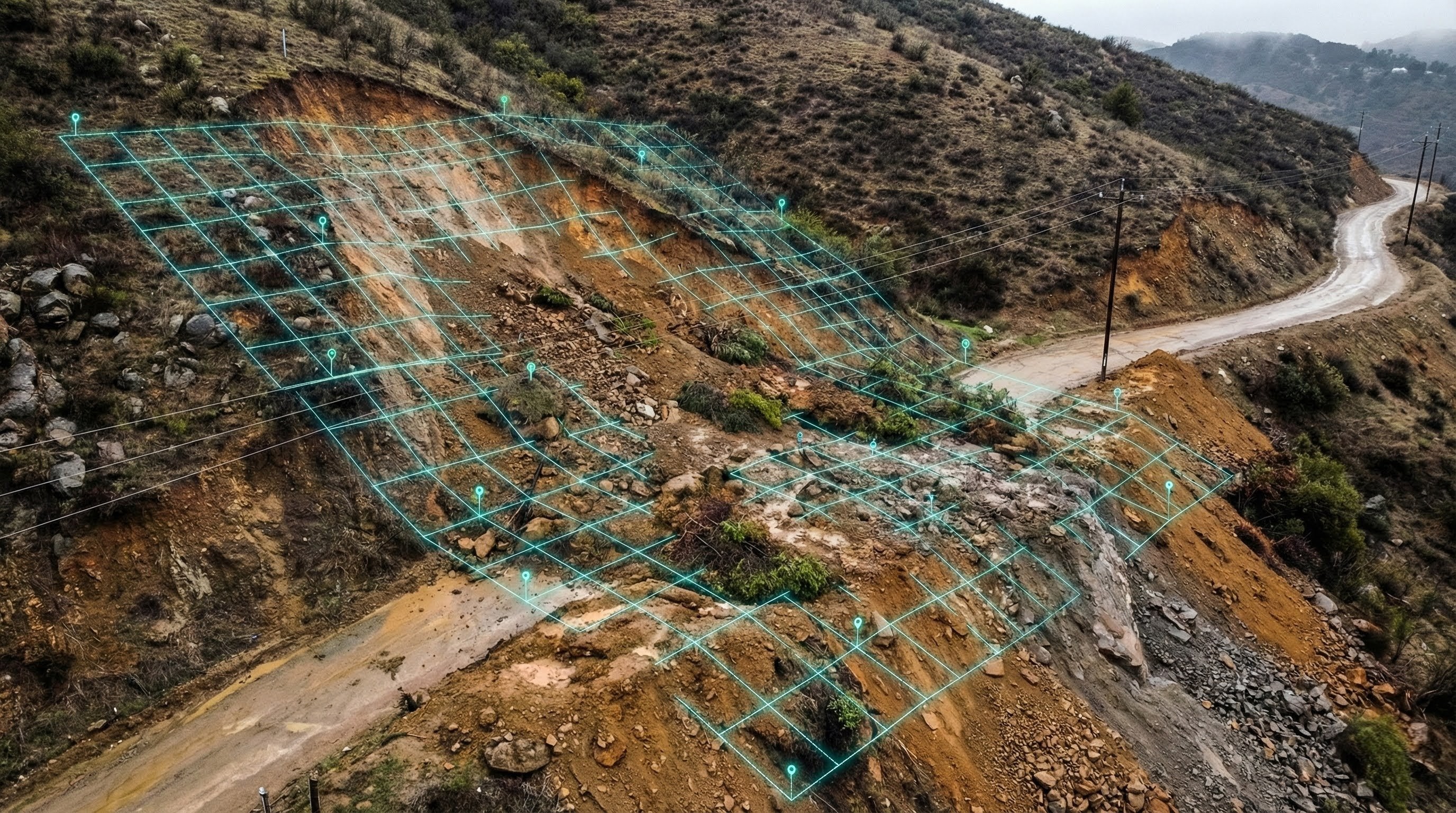
Visual Evidence Packages
Interactive before/after viewer with downloadable proof for reports. Maps directly to exact areas of concern.
Complete History & Audits
Full time-series retention with trend reporting for engineers and executives. Searchable audit trail for every event.
Multi-Interval Confidence
Short and long baseline comparisons with confidence scoring that reduces false positives. Automatic escalation for critical findings.
Precision Alignment
Stabilizes every frame for fair comparison. Balances lighting and color automatically, highlighting subtle motion engineers care about.
Managed Operations
Custom regions and schedules per site. Health checks, auto-resume logic, and team notifications via email or API.
See It in Action
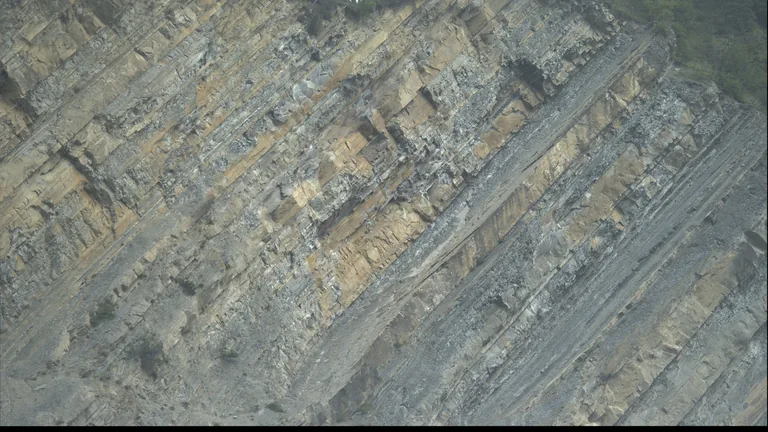
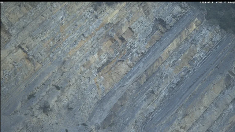
Visual Change Detection
Every detected change is mapped, visualized, and linked to the original imagery for immediate verification.
- Shareable before/after views that prove every alert
- Highlighted regions show exactly where change occurred
- Optional expert review and reporting packages


Where Teams Deploy IRIS for Geotechnical Monitoring
Built for landslide monitoring, rockfall detection, and slope surveillance, yet flexible enough for any geotechnical monitoring use case.
Geohazards & Slopes
Early warning for landslides, rockfalls, and slope instability.

Rockfall detection
Spot rocks and debris accumulating on slopes before they mobilize.

Slope deformation
Track progressive movements on hillsides and cut slopes over time.

Dam & structure cracks
Detect new cracks or propagation on concrete faces and spillways.

Coastal cliff retreat
Measure shoreline erosion and cliff recession between surveys.

Debris flows & avalanches
Monitor channels and chutes for sudden debris or snow movements.
Infrastructure & Operations
Monitor transportation corridors and critical assets.

Railway rockfall & track obstructions
Detect rocks, debris, or objects on tracks before trains approach.

Highway rockfall zones
Monitor mountain roads and tunnel approaches for fallen debris.

Tunnel portals
Watch portal faces and approach cuts for rockfall and instability.

Mining pit walls
Monitor open pit benches and highwalls for slope failures.

Construction excavations
Track temporary slopes and excavation faces during works.
...and if you need new cameras, our field engineers handle surveys, installation, and maintenance.
Trusted by infrastructure leaders
Teams around the world rely on NHAZCA for critical ground deformation and change detection monitoring.


Ready to see IRIS in action?
Whether you bring cameras, point us to remote archives, or need a turnkey install, we'll help you detect landslides and rockfalls before they become hazards.
Prefer email? info@nhazca.com • nhazca.com
IRIS AI Change Detection – FAQ
Quick answers about cameras, deployment, AI change detection and how IRIS fits into your geotechnical monitoring and early warning workflows.